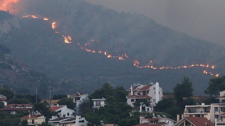
Footage from a plane taking off from the Athens International Airport on Monday morning shows the extent of the forest fire raging in the north and east of Athens.
@venisapka
The fire that began on Sunday in the town of Varnavas, northeast of the Greek capital, has spread southwards overnight. Officials say that in less than 18 hours, the flames engulfed an area of at least 20 kilometers.

Three main fronts in Athens forest fire
According to an update from the fire department on Monday morning, the fire-fighting effort is extremely difficult, as the direction of the wind keeps changing. The three main fronts of concern are Grammatiko, Penteli, and the Anatoli settlement in Nea Makri.
The forces deployed against the flames have been increased to 560 firefighters, with 16 teams of forest commandos and 177 vehicles, while 32 aircraft (17 airplanes and 15 helicopters) are operating from the air.
The fast-moving blaze, fueled by hot and windy conditions, has already destroyed trees, homes, and vehicles, and sent thick clouds of smoke over the city.

Evacuation orders were issued beginning in the early hours of Monday morning for the areas of Nea and Palia Penteli, Drafi, Dioni, Damarasi, Daou Penteli, Agios Spyridonas, and Anatoli in Nea Makri. Authorities have also evacuated two hospitals in Penteli and the monasteries of Agios Ephraim and of Penteli. The police have assisted in the evacuation of dozens of people at risk due to the fires.
One firefighter was injured while fighting the fire in Marathon, suffering second degree burns to his hands and legs. He was first taken to the Nea Makri health center and then the 251 Air Force General Hospital.
Forest fire danger forecast on Monday in Athens
A class five (extreme) level of fire danger is forecast in three regions of Greece on Monday, including Attica, according to the Fire Danger Forecast Map issued by the General Secretariat for Civil Protection of the Climate Crisis and Civil Protection Ministry for Monday, August 12.
In addition to Attica, a class five fire danger is forecast in Viotia and Evia in the Central Greece Region and in Argolida, Corinth and Lakonia in the Peloponnese Region.
Very high (class 4) fire danger is also forecast in Evros, in the Eastern Macedonia-Thrace Region, the Sporades islands in the Thessaly Region, in Fokida, Viotia, Fthiotida, Evia and Skyros in the Central Greece Region, in Achaia and Ilia in the Peloponnese Region, in the Western Greece Region, the Cyclades islands in the Southern Aegean Region and the Crete Region.
All state services involved and the regional and municipal authorities in the above areas have been informed to be on high alert to deal with any incidents, while citizens are advised to exercise extreme caution and avoid any actions outdoors that could lead to a fire through negligence, such as burning vegetation, using machinery that creates sparks, lighting fires, smoking bees and similar actions.